The very fiber of a neighborhood is intertwined within the aspects which make it unique. The road layout of a neighborhood, the buildings and services located within it, the people who live in the neighborhood, the transportation, the placement of parks and other green spaces, and other similar aspects are all what make a neighborhood unique from another. The way these aspects connect, and the way the neighborhood uses these aspects to grow and advance, gives an insight towards how urban sustainability is present in the neighborhood, and how change occurs over time.
This is the case for both bustling urban neighborhoods and quiet suburban neighborhoods, and those in-between: Gravesend, Brooklyn is a prime example of a New York City neighborhood caught in these crosshairs, as it isn’t a bustling urban neighborhood with tourists and skyscrapers, but one of a more suburban nature, where neighbors care for each other and residents live about their lives. Gravesend, being my home neighborhood, is the one which this article will focus on.
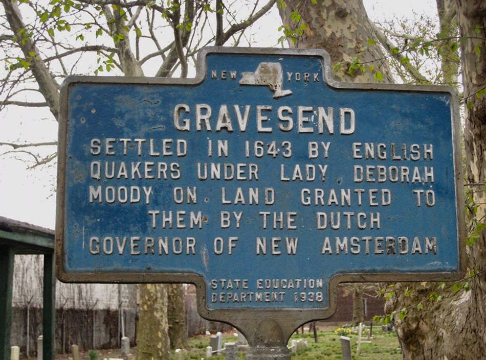
Gravesend is a neighborhood located in southern Brooklyn, bordered by the iconic Coney Island to the south, Bath Beach to the northwest, Bensonhurst to the north, Midwood to the northeast, and Sheepshead Bay to the east. Named for the village of the same name in England, Gravesend also gets its name from the historic Gravesend Cemetery settled way back in 1643, where the founder of Gravesend, Lady Deborah Moody, is said to be buried.
Wandering past the cemetery, as I used to do on many evening strolls to my grandparents’ house, which is located a couple of blocks from the cemetery, you get an insight as to how old the neighborhood really is, with many of the gravestones reading dates long before the United States was even founded, dating well into the 17th century.
Regardless, Gravesend has become known as a working and middle-class neighborhood tucked between larger neighborhoods, often those which are more prominently known, such as Coney Island. I’ve had many instances where Brooklynites themselves hadn’t even heard of Gravesend when I told them I was from there. However, the neighborhood of Gravesend is well-loved by its residents — over 30,000 strong — and the neighborhood has seen both relative change and preservation over the past eighty years, as evident by three vital resources which have mapped New York City over time: 1940s.nyc, 80s.nyc, and of course, Google Street View.
Gravesend has seen quite a few alterations over these time spans, which have propelled its urban growth and sustainability, and the primary focuses regarding this matter will be with the neighborhood’s housing, shops and businesses, transportation, and brownfields and green spaces.
Beginning with Gravesend’s housing, the neighborhood is, as mentioned, a more suburban neighborhood than others in Brooklyn, particularly in northern Brooklyn, and this has pretty much always been the case. Gravesend primarily consists of two types of homes: private, two-story homes, and six-story brick apartment buildings typical of numerous neighborhoods in New York City. The presence of the apartment buildings in Gravesend is itself a representation of the urban change that has occurred in the neighborhood, fueled mostly by a growing population.
In the early 1940s, prior to the United States’ entry into World War II, Gravesend consisted of smaller, single-family homes towards its southern end, roughly south of Avenue U, and larger single-family homes in its northern end, roughly north of Avenue U. This still remains today, but one factor that doesn’t remain is the large presence of empty lots which Gravesend contained during this time period.
By looking around Gravesend on 1940s.nyc and taking note of the locations of the empty lots, and then comparing them to today, you will notice that most of these lots are where these six-story brick apartment buildings now lay. A prime example of this is East Third Street, between Avenue W and Avenue X: in the early 1940s, the corner of Avenue X and East Third Street (the lot located on the right-hand side of the left photo below) was a mere dirt lot, but today, it is one of many brick apartment buildings, as you can see in the comparison.

This boom in apartment buildings was most likely a result of the post-war population boom, and thus is an example of urban change in Gravesend: as the population of the city increased following the war, demand increased and the need for more housing became prominent. No longer would Gravesend be a neighborhood consisting of mere private residences, for the numerous empty lots in the neighborhood offered a solution: build up. This may offer an explanation as to why almost all of the apartment buildings and complexes in Gravesend, such as the Beach Haven Apartments near the Belt Parkway, built in 1949 as its sign indicates, feature this same brick design.
One exception to this, while still featuring the brick design typical of New York City during the mid-20th century, is the Marlboro Houses, a public housing project built in the 1950s. The Marlboro Houses are the only NYCHA housing project in Gravesend, located on the southwest side of 86th Street, northwest of the Coney Island Complex, which will be discussed later. As the Marlboro Houses were built in the 1950s, they were large vacant lots in the 1940s, as evidenced by the comparison photo below. The April 2011 PlaNYC housing report states:
“NYCHA began building tall towers surrounded by open space and parking lots beginning in the 1940s, [and] the result often interrupted the continuity of neighborhoods and retail corridors, and too often left NYCHA developments as islands isolated from the broader community.”
This almost perfectly describes the Marlboro Houses, as they never really ‘fit in’ with rest of Gravesend, feeling like a neighborhood of their own, and are plagued with their own problems. The fact that the Marlboro Houses, as well as numerous other NYCHA housing projects, still suffer from these problems today are an indication that they are not sustainable in the long term.
Gravesend is arguably both a working-class and middle-class neighborhood. The neighborhood is mostly working-class, home to a mix of row houses and apartment buildings. However, a smaller pocket of the neighborhood, roughly bordered by Avenue U to the south, Kings Highway to the north, Ocean Parkway to the east, and McDonald Avenue to the west, is the middle- and upper-class portion, where you will find numerous private houses, luxury vehicles, and almost no apartment buildings.
This difference between this part of the neighborhood and the rest of Gravesend is visually apparent on Google Maps, looking from a top-down satellite view: the wealthier area contains a plethora of red Spanish-tile roofs and tree-lined streets, in contrast to the rest of the neighborhood featuring standard gray roofs and minimal tree-lined streets. The difference in Gravesend between the 1940s and 1980s (and today) is extremely apparent, but the neighborhood has physically not changed much since 1980, with many of the homes, buildings and businesses remaining the same, save for a few exceptions.
Unlike many other Brooklyn neighborhoods, particularly in the north, Gravesend has not experienced much gentrification and as such has changed minimally over the years. This is evident in the neighborhood’s shops and businesses: Avenue X between Ocean Parkway and McDonald Avenue is my area’s commercial strip, where residents often walk along the avenue, in-and-out of the numerous shops and businesses.
Here in 1940, one would find locally-owned businesses such as pharmacies, bakeries, meat markets, and grocers. In 1980, one would still find these same businesses, along with new ones: discount stores, pizzerias and laundromats, such as Bargain Mart, Avenue X Laundry & Dry Cleaners, and Cirro’s Pizza, respectively. And today in 2021, almost all of these businesses still remain: Cirro’s has become a Middle-Eastern meat market, but the laundromat and discount store — renamed R&K Discount — still remain.
The presence of small, locally-owned shops and businesses is a core element of Gravesend and its residents, and the fact that many have remained in Gravesend through to the present day is an indication that the neighborhood has not received dramatic urban change in regards to its class and demographics, and may not for the foreseeable future. Its businesses are already sustainable.
Moving on to another critical aspect, transportation is a core element of New York City and its boroughs, and its usage in the city and integration with the neighborhoods which it passes through is an indicator that effective public transit is vital for a community. This is no different with Gravesend, which is served by multiple bus and subway routes: The B1, B3, and B4 buses are the primary bus routes of the neighborhood, with others passing through of course, while the D, F, and N trains serve as Gravesend’s subway lines, offering residents a quick route to Manhattan and possibly beyond.
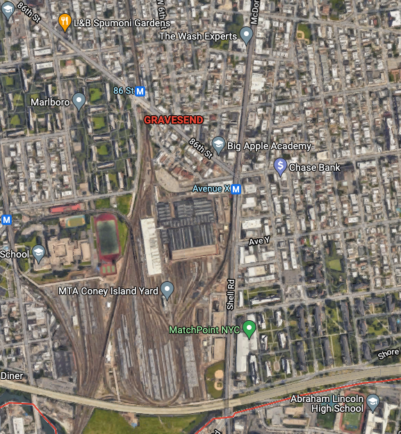
Gravesend does serve as an important destination for the New York City Subway system, though, as the Coney Island Complex is located there, taking up a significant chunk of the neighborhood. The Coney Island Complex, also known as the Coney Island Yard, is the largest rail yard in New York State, and, according to NYC.gov, “one of the largest subway maintenance and storage yards in North America”. The Coney Island Complex was present in 1940, as “the yard was built on swampland and opened in 1926”, again according to NYC.gov, and it has only grown in size since, allowing Gravesend to play a prominent role in the functioning of the city’s transit system.
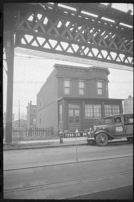
One aspect of transportation previously present in Gravesend, but no longer, are streetcars. Once prominent across New York City as a whole, streetcars were a staple of New York City and, of course, ran through Gravesend as well. According to Joan Fitzgerald, author of Emerald Cities: Urban Sustainability and Economic Development, they “[were] easy to add, as the cars and track are relatively narrow” and this was evident with Gravesend’s primary streetcar route, which ran underneath the elevated Culver Line along McDonald Avenue, along the stone-paved road.
The presence of this streetcar line is evident in a number of photographs, including the one below, which shows both the streetcar track and the elevated train above it. Sadly, streetcars faded out of existence, mostly due to private auto companies such as GM buying all of the lines and removing them in favor of an automobile-oriented nation. This is an example of a core element of Gravesend which has been erased, as remnants of the streetcar or its track no longer exist in Gravesend (there is a portion of Ocean Avenue where parts of the track are still visible, but this is outside of Gravesend).
The demolition of a prominent icon that is the streetcar demonstrates that transportation is in fact an important factor of the urban sustainability of a neighborhood — the removal of the streetcar may not have had such a large effect in Gravesend because other transit options exist, such as buses and the aforementioned Culver Line, which runs right above where the streetcar used to. In this way urban change has occurred in Gravesend, with a prominent means of transportation and an icon of the neighborhood during the time being erased from physical existence.
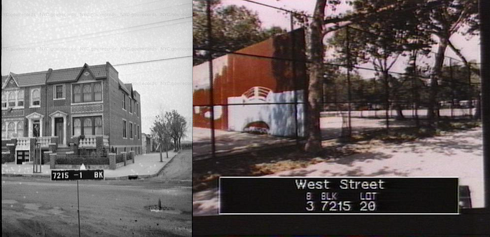
As discussed earlier, a once prominent feature of Gravesend was its numerous undeveloped plots of land, which were mostly turned into brick apartment buildings and other smaller homes. It can be argued that the demand for housing and affordable living space supplanted the neighborhood’s recreational potential, as Gravesend to this day is really only home to one prominent green space: the West Playground, located on Avenue Z between West Street and West 4th Street.
This is the only green space in my area, with the others being located elsewhere in Brooklyn that I’d have to drive to. Many childhood memories of mine were created at the West Playground, with my friends and I constantly playing on the swings and slides, and running around the primary water fountain which would shoot water high into the air in the summertime. The park did not exist in the 1940s, having been built later, and although no proper image of the space is available, you can see that in the photo below, the empty area behind the house in the 1940s where the playground roughly lies, was turned into a park by 1980, and looks very similar to this day, except for the turf track-and-field which was installed in the late 2000s.
Regardless, this is the only proper recreational green space in my area, and it shows that during Gravesend’s development, green space unfortunately took a backseat in favor of housing and residential development. There was plenty of empty land in Gravesend in the 1940s, but none of them became parks except for the West Playground.
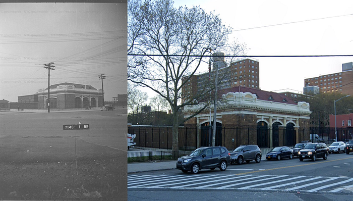
Finally, it is important to discuss the presence of brownfields in Gravesend. As we know, a brownfield refers to a plot of land which is unusable in its current state due to contamination. Almost every neighborhood in a major city usually has a few, and my parents and grandparents who also grew up in Gravesend have told me that the neighborhood had a few before I was born, but most have been re-developed now. One example of a brownfield in Gravesend which was recently developed, however, was the site on the corner of Avenue X and 86th Street, right across from the Coney Island Complex, which was previously a gas station, was a brownfield for a long time, and then recently was converted back into a gas station.
There is no imagery of the site in the 1940s, leading me to believe that it wasn’t yet developed, but in the 1980s, it was a gas station. My mother has told me that she used to travel there as a kid with her parents to fill up the car with gas, but it closed when she was younger and the site remained an abandoned brownfield from that time until 2019, when it was converted into another gas station.
With another gas station located right across the street (which did exist in the 1940s and has always existed since that point), the gas station that closed was not sustainable, and it took a while for urban change to occur in this area, with the building of another gas station over thirty years later. This can also show us that brownfields are extremely tedious to redevelop, especially into something that the brownfield previously wasn’t, such as a residential or commercial development. In this case, the easiest solution was to turn the decaying property into another gas station, and so that is what was accomplished.
Saying that urban change has not occurred in Gravesend is an incorrect statement. Saying that urban change in Gravesend has stalled in recent decades, or has been extremely minimal, may be more accurate. As long as I can remember, my area has remained the same, both physically and demographically — my grandparents tell me that the area used to be much more Italian and Irish, and much of those people have moved away to other places, but that is expected of numerous neighborhoods in New York City, which have strong European roots.
Regardless, Gravesend boasts healthy public transit infrastructure and a very strong reliance on small local businesses, but a minimal amount of green spaces. All of these factors can provide insight into the urban sustainability of the area, which had and still has a strong focus on working-class housing, as well as Gravesend’s unique urban changes over time.
Gravesend, Brooklyn: stayin’ classy since 1643, and still going strong.
Chris is a writer and publisher who travels America, and loves doing it. He also loves pizza, video games, and sports, and can tell you a thing or two about each. Follow him on Medium to be informed of new articles.